

Grays Harbor, WA: APN: 191227210120
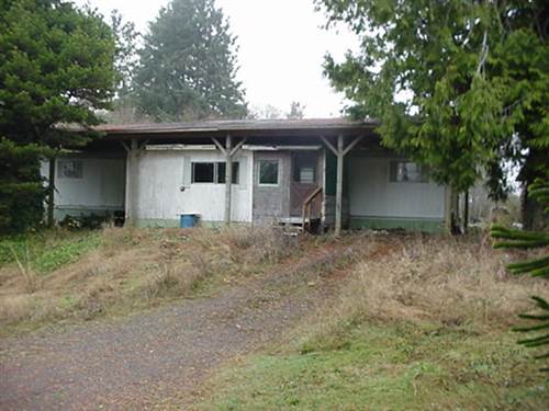
| Seller Name: | GHCTreasurer |
| Rating: | Not Applicable |
| Location: |
51 VIEWCREST DR Copalis Beach, WA 98535 |
This is a NO RESERVE auction


| The Grays Harbor County, WA Treasurer offers tax foreclosed property for auction and encourages bidders to research the property thoroughly using the following information as a starting point. |
Deposit Requirement |
|
Disclaimers |
|
| Parcel Information | |
|---|---|
| APN | 191227210120 |
| County Item No | 75 |
| Legal Description | Parcel A: Beginning at the 1/16th corner on the West line of the Northeast Quarter of the Northwest Quarter of Section 27, Township 19 North, Range 12 West of the Willamette Meridian; Thence North 89º 55' East 329 feet; Thence North parallel to the West line of said Section 358.2 feet; Thence North 89º 50' West 332.3 feet, more or less, to the West line of the Northeast Quarter of the Northwest Quarter of said Section; Thence South along the West line of the Northeast Quarter of the Northwest Quarter of said Section 359.6 feet to the place of beginning; EXCEPT those portions of above described tract described as follows: Beginning at the Southwest corner of said subdivision, North 3º 6' 3" East along the West line thereof 359.60 feet of the South margin of Hoquiam Street, presently 60 feet in width; Thence South 86º 48' 5" East along said street margin 220 feet to the true point of beginning; Thence continuing South 86º 48' 5" East along said street margin 109 feet; Thence South 3º 6' 3" West parallel to the West line of said subdivision 150 feet; Thence North 86º 48' 5" West 109 feet; Thence North 3º 6' 3" East 150 feet to the true point of beginning; ALSO EXCEPT the East 120 feet of the West 220 feet; EXCEPT the South 115 feet thereof; AND EXCEPT the West 60 feet of the North 120 feet of the South 235 feet thereof; ALSO EXCEPT beginning at the 1/16th corner on the West line of said Northeast Quarter of the Northwest Quarter; Thence North along the West line of said Northeast Quarter of the Northwest Quarter 230 feet to the true point of beginning; Thence North 89º 55' East 100 feet; Thence North parallel to the West line of said Northeast Quarter of the Northwest Quarter 100 feet; Thence West at right angles to last described course 100 feet to the West line of said Northeast Quarter of the Northwest Quarter; Thence South along said West line of the Northeast Quarter of the Northwest Quarter to the point of beginning; ALSO EXCEPT commencing at the Southwest corner of said subdivision; Thence North 3º 06' 03" East along the West line thereof 330.00 feet to the true point of beginning; Thence continuing North 3º 06' 03" East along said West line 29.60 feet to the South margin of Hoquiam Street (unimproved) presently 60.00 feet in width; Thence South 86º 48' 05" East along said street margin 100.00 feet; Thence South 3º 06' 03" West, parallel with the West line of said subdivision, 29.17 feet; Thence North 87º 02' 42" West, parallel with the West line of said subdivision, 100.00 feet to the true point of beginning; ALSO EXCEPT the North 50 feet of the South 230 feet of the West 100 feet; ALSO EXCEPT the North 65 feet of the South 180 feet of the West 100 feet; ALSO EXCEPT the East 60 feet of the West 160 feet of the North 120 feet of the South 235 feet; ALSO EXCEPT beginning at the 1/16th corner of the West line of Section 27, Township 19 North, Range 12 West of the Willamette Meridian; Thence Northerly 115 feet; Thence Easterly 100 feet; Thence Southerly 115 feet; Thence Westerly 100 feet to the point of beginning; ALSO EXCEPT the South 115 feet of that portion of the Northeast Quarter of the Northwest Quarter, EXCEPT the West 164 feet thereof, AND EXCEPT the East 110 feet thereof; ALSO EXCEPT the East 64 feet of the West 164 feet of the South 115 feet; ALSO EXCEPT the East 110 feet of the West 329 feet of the South 115 feet; Situate in the County of Grays Harbor, State of Washington. Parcel B: A non-exclusive easement for roadway purposes of ingress and egress, as contained in instrument executed by Harold E. Phelps and Ethel B. Phelps, husband and wife, dated June 16, 1967, filed June 30, 1967 under Auditor's File No. 190065 in Volume 470 of Deeds, page 357, records of Grays Harbor County; Situate in the County of Grays Harbor, State of Washington. |
| Address | 51 VIEWCREST DR Copalis Beach, WA 98535 |
| Acreage | 0.23 |
| Parcel Image | View Parcel Image |
| Parcel Image 2 | View Parcel Image 2 |
| Parcel Map | View Parcel Map |
| GIS | View GIS |
| Add'l Information | |
| Assessed Values | |
|---|---|
| Assessed Values From | 2023-2026 |
| Improvements | $10,096.00 |
| Land Value | $10,000.00 |
| Personal Property Value | $0.00 |
| Total Assessed Values | $20,096.00 |
| Tax Bill | |
|---|---|
| Ad Valorem | $687.88 |
| Total Tax Bill | $2,101.86 |
| Tax Bill Year | 2023-2026 |
| Additional Information | |
|---|---|
| Tax Rate Area | 064F07 H2 |
| Tax Rate | 8.205413300% |
| Zoning Code | COUNTY R3 |
| Zoning Type | RESORT RESIDENTIAL |
| Improvement Bonds | 0 |
| IRS Liens | No |
The due diligence items below apply to all related auctions from this seller.
General Sale Information
End of Auction
After the close of the final Grays Harbor County, WA listing for auction, all winning bidders are sent detailed instructions via e-mail on settlement procedures and how to provide the county with the necessary deed transfer information.
Grays Harbor County, WA requires that the winning bidder submit the deed transfer information to Bid4Assets within 24 hours of the close of auction.
To bid on this auction, all bidders are required to become qualified by placing a deposit. The deposit of the winning bidder is automatically transferred to the seller at the end of the auction. If the winning bidder fails to perform on any auction, the entire BidDeposit will be forfeited to the seller. Non-winning bidder deposit refunds are mailed within ten (10) business days after the close of the auction. This deposit cannot be applied to other auctions. To find out more about the BidDeposit requirement, click here.
Full payment must be received by Bid4Assets no later than 4:30 PM ET (1:30 PM PT), Tuesday, December 8, 2026. If the payment policy is not adhered to, the winning bidder will forfeit their deposit and may be banned from future sales.
A $15.00 deed preparation fee, a $10.00 real estate excise tax processing fee and recording fees of $303.50 for the first page and $1.00 for any additional page of the deed will be added to, and collected with the full purchase price. Additionally a $35 per-parcel-won administrative fee will be added to the final Sale Price.
- Certified/Cashier's Check
- Wire Transfer